Monday we left the trailer parked at the RV park, packed up the tent and our pups and headed out to explore east of Portland. We decided to do a three day, two night loop, starting along the
Columbia River Gorge, driving along the waterfalls route, an overnight stop in Hood River, then through the Fruit Loop to Mt. Hood, with one more overnight stay on the mountain. I had originally planned to make this one big post, but we saw so many amazing things that it was not possible to squeeze everything into one. I decided on the two part approach, so hence, this is Part 1.
We had a handy Mt. Hood Scenic Loop brochure and map that we'd gotten from the Portland visitor's center that we used to plan this trip, and we were following most of the suggested stops. I would highly recommend printing this map (page 1 and page 2), as we found it to be very helpful. We started our route by taking hwy 84 out of Portland. About 20 miles in we turned off the new highway and drove onto the Historic hwy 30 route. In
Troutdale, also known as the Gateway to the Gorge, we made our first stop to pick up a cup of coffee and walk the downtown strip.
 |
| Driving along the historic highway 30 |
 |
| Walking around in Troutdale |
F
rom there we proceeded along the charming historic highway to the Women's Forum Overlook site. There we found amazing views of the gorge.
 |
| Views of the Gorge from the Women's Forum Overlook |
The third stop was the Crown Point Vista House, that is a national historic landmark, and also has amazing views of the gorge. If you're going to get pictures of the gorge, take them at either of these locations, as after these two spots you head into the forest and start the waterfalls tour.
 |
| View of Crown Point Vista House from Women's Forum Overlook |
 |
| At the Vista House |
Following the Vista House we came upon a succession of beautiful waterfalls. There are over 70 waterfalls on the Oregon side of the Columbia river, and the historic highway takes you along most of them on its short 15 mile stretch. All the waterfalls had parking spaces, and most required a short hike to the falls themselves. We stopped at Bridal Falls, Wahkeena Falls, Multnomah Falls and Horsetail Falls.
 |
| Bridal Veil Falls |
 |
| Wahkeena Falls |
 |
| Horsetail Falls |
I had heard about Multnomah Falls, the tallest waterfall in Oregon at 611 feet, and had imagined it to be the prized waterfall on this route. It did not disappoint, but I have to say the other waterfalls we saw that day were just as impressive in their own ways.
 |
| Multnomah Falls |
Highway 30 meets back up with highway 84 after passing Ainsworth State Park. Our next stop was the Bonneville Dam. We drove up to a loud roaring sound, which turned out to be water rushing through the dam.
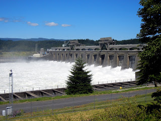 |
| Bonneville Dam |
The Dam is also the home to a fish hatchery and fish ladders for counting Salmon as they swim up the river. We toured the ladders and then went downstairs to the viewing windows to watch the fish swim underwater. Then we drove to the hatchery to see Herman the Sturgeon, the 70 year old 11 foot sturgeon that lives there.
 |
| This year's fish count at the Bonneville Dam |
 |
| Watch the salmon swim through the fish ladder! |
 |
| Herman the Sturgeon |
We rounded out the day by driving by the Bridge of the Gods (where the Pacific Crest Trail crosses from Oregon to Washington), and then setting up our tent camp at Viento State Park. We picked Viento because of its close proximity to the city of Hood River.
 |
| Bridge of the Gods |
The next day we set out to explore Hood River and make our way to Mt. Hood, but more on that in Part 2!
To see more pictures of the Gorge and the waterfalls, click
here.
Happy Gorge Driving,
M.


No comments:
Post a Comment